
Our Response to the
City of Long Beach
Notice Of Preparation for 3701 Pacific Place
The following NOP (Notice Of Preparation) document is from Riverpark Coalition’s response to the City Of Long Beach, submitted July 7, 2023.
TO: Ms. Amy L. Harbin,
AICP Planner City of Long Beach
Development Services Department
411 West Ocean Blvd., 3rd Floor
LBDS-EIR-Comments@longbeach.gov
562.570.6872
FROM: Riverpark Coalition
REGARDING: NOP Comments Application Number 2304-33 (EIR 02-23)
Project site 3701 Pacific Place in the City of Long Beach in Los Angeles County
The Riverpark Coalition is a non-profit 501c3 organization that seeks to remedy the park equity issues in the City of Long Beach. Open space, parkland and trees are needed for public respite and leisure but more importantly to cleanse the air that is polluted by port traffic along the 710 freeway.
Sections or partial sections taken from the NOP are in quotes and italicized.
Please accept our comments below.
GENERAL COMMENT: The notice of the NOP meeting and timeframe for comment was not widely enough distributed and a 2nd NOP meeting should be held with the due date for comments appropriately extended. The school and PTA should have a chance to comment. The DTSC would normally have held community meetings as well providing information on when the public could participate but they only found out about the NOP when the public notice was delivered.
REQUEST 1) Please extend the NOP comments period and ensure affected neighbors have been notified to include the school and PTA as well as neighborhood associations and residences. The project summary description (see below) should be amended to ensure the public is aware of the site history and that dangerous toxins may be released during testing, grading, construction and landscaping.
PACIFIC PLACE – PROJECT SUMMARY
NOP quote: “The existing Project site is vacant and was used as a golf driving range in the mid-2000’s … “
COMMENT: The PROJECT SUMMARY description fails to include the most critical part of the site’s history – mainly that Oil Operators, Inc. used this land as a toxic waste disposal site (oil sump pond) from 1926 to the 1950s. It also accepted effluent from the City of Signal Hill sewage treatment plant. This area is considered to be a “brownfield .” Ostensibly, there could be soil problems up to 50 feet in depth with oil residue, hazardous chemicals, and resultant gases emitting from the site. Arsenic and TPH chemicals were evident even on the top layer of soil with signs posted (see illustration 1 below) on the site by the So Coast Air Quality Management district warning the public of airborne pollution. Department of Toxic Substances Control (DTSC) reports validated the dangerous chemical content of the soil (but only at a shallow depth).
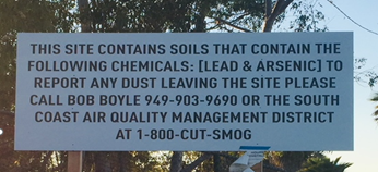 Illustration 1 South Coast AQMD SIGNAGE AT 3701 PACIFIC PLACE – 2020
REQUEST 2) We ask that you include the above pertinent site history in the project summary.
NOP quote: “Most of the Project site slopes slightly toward the south and elevations onsite range from 38 to 71 feet above mean sea level (AMSL).”
COMMENT: The developer graded the site and deposited soil for a surcharge test raising the soil height artificially (ground level raised approximately 9 – 15 feet) in the southern corner of the site. It is estimated that 40,000 cubic yards of additional soil weighing 100 million pounds were moved onto the site.
- The surcharge soil height addition was not calculated into the height variance.
- The neighbors were supposed to be warned of the dust containing hazardous chemicals on the day of the grading and they were not.
- The surcharge pile was supposed to be covered and was not.
- After test results were complete, the soil surcharge pile was supposed to be removed and was not.
REQUEST 3) The fact that the elevations vary and the surcharge test contributed to the unnatural height needs to be included in the Project Summary/Existing Setting as well as in the EIR.
REQUEST 4) Calculations for a building height variance need to reflect the conditions before the surcharge mound was installed. Storypoles need to be installed with signage to advise the public of the proposed height.
REQUEST 5) The surcharge soil should be removed. Air quality should be monitored throughout the removal of the pile. The neighborhood should be warned about possible pollution/dust during operations. If the surcharge pile is not removed it should be covered.
Land Use and Zoning
NOP quote: General Plan and Zoning “The City of Long Beach Zoning Designation for the Project site is Light Industrial (IL). The General Plan designation for the Project site is Neo-Industrial (NI). Approval of the proposed project would require an amendment to the City of Long Beach General Plan PlaceType change from Neo-Industrial (NI) to Community Commercial Centers and Corridors (CC) and related General Plan map updates, a Zone Change from Light Industrial (IL) to Commercial Storage (CS), Site Plan Review, Standards Variance, three (3) Conditional Use Permits, Vesting Tentative Parcel Map, and Sign Program.
“Alternatives to the Proposed Project CEQA Guidelines Section 15126.6(a) requires that, an EIR describe a range of reasonable alternatives to the Project, or to the location of the Project, which would feasibly attain most of the basic objectives of the Project but would avoid or substantially lessen any of the significant effects of the Project and evaluate the comparative merits of the alternatives.” Project alternatives will include the CEQA-required No Project Alternative and other alternatives to be developed once the technical analyses are completed and there is an understanding of the Project’s objectives and potentially significant impacts.”
The clause above in red indicates that only alternative projects that only relate to warehouse storage should be considered.
REQUEST 6) Alternatives: Consider off-site alternatives, on-site alternatives that maximize public greenspace and minimize the project footprint, and on-site alternatives that have far reduced intensity of uses (for example, omitting two stories of the self storage building, halving the RV parking stalls, omitting one of the Project uses, etc)
COMMENT: Just the changes required from the most current land use designation and zoning illustrate that the plan for this area is not in alignment with the current General Plan and Zoning.
COMMENT: For decades, civic planners have identified the most environmentally viable and beneficial use of this land as future public urban greenspace, desperately needed in this part of western Long Beach which is so densely populated with working class families in high density housing and so bereft of any sizeable tracts of public open space for recreation and rejuvenation.
Up until 2019, this area was designated for open space/parkland.
-
- Nov 1, 2019: Three Parcels closed escrow under council-approved City General Plan placetype: Open Space
- Dec 2019: Draft LUE—which was available for public review and comment—reflects placetype: parks, however an addendum that was not made available for public comment accompanied that draft. This addendum changed it to placetype: neo-industrial.
- March 23, 2020: Fourth Parcel closed escrow under council-approved LUE placetype: Neo-Industrial
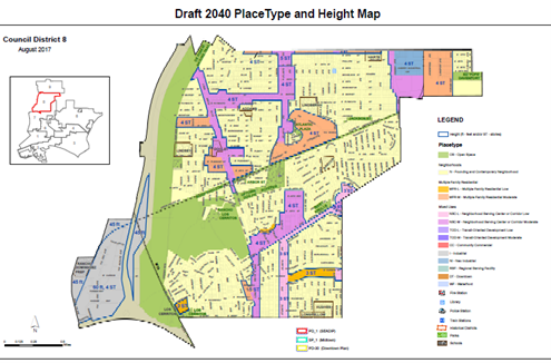
Illustration 2: 2017 Proposed Placetypes Map (LUE)
The site was identified in multiple plans as planned open space/parkspace along the LA River for the last 50 years. Some of those plans are listed below:
-
- 1973: Parcels 712 Baker and 3701 Pacific Place (and 3 others on the LA River) were identified to be developed into the Westside’s open space (City of Long Beach General Plan, Open Space Element)
- 1989: The Recreation Commission included these lots in their park acquisition plan.
- 1996: Designated as “open land proposed for park” in LA County’s Los Angeles River Master Plan
- 2000: Trust for Public Land grants $2M specifically for the purchase of 712 Baker and 3701 Pacific Place
- 2002: Open Space and Recreation Element – LB General Plan identifies uneven distribution of open space p. 23 and shrinking open space
- 2007: Long Beach RiverLink Plan adopted, Long Beach Parks and Recreation.
- Aug 2015: Long Beach RiverLink Plan update unanimously approved by LB City Council
- 2015 the Lower Los Angeles River Revitalization Plan
- 2016 the Los Angeles Countywide Parks & Recreation Needs Assessment (2016)
- 2020 LA County Los Angeles River Master Plan
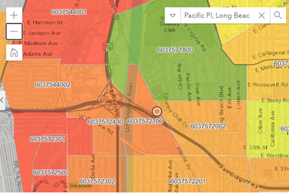
COMMENT: The LA River Masterplan shows Pacific Place as a “Planned Major Project” in the Long Beach segment of that regional plan.
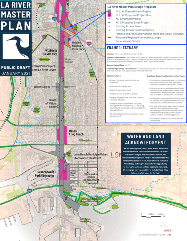
Illustration 3 – LA River Masterplan Map (2021) Pacific Place designated “Major Project”
REQUEST 7) Document open space/parkland as an alternative use.
REQUEST 8) A thorough study must be undertaken of all the longstanding river and park space planning documents over the last several decades which have included this land as proposed future park space or revitalized public open space. A a historical accounting of all the plans that identified the land for open space/ park space should be included in the EIR.
Aesthetics:
“Project site would be developed with a four-story, 206,756-sf self-storage building consisting of approximately 1,681 self-storage units on four levels.”
COMMENT: The requirement for the current placetype and zoning is 2 stories. The surrounding neighborhood is two stories. The height limitation proposed for the self-storage building was 3 stories in the MND and has been changed to 4 stories for the current project. The depiction below shows the non-conforming character of placing this business about 100 feet from a City Park, Elementary School and residences with signage that would dwarf the surrounding structures in the neighborhood. Note: The below illustration was taken from the Developer documentation when the project was planned for 3 stories.
Illustration 4: Proposed Signage & Structures as 3 stories
REQUEST 9) Include a to-scale comparison illustration of the proposed business structures at the 4 story height with the surrounding:
• neighborhood residences,
• park and
• school
and address the non-conforming nature of the project in this location.
AIR QUALITY
COMMENT: Historically, volatile and semi-volatile organic compounds, methane, benzene (which causes leukemia) and other flammable gases have been recorded at this site (along with heavy metals including lead).
Request 10) The current status of gaseous emissions should be tested. The surcharge test soil pile needs to be removed prior to collecting that data. Note: The term “clean up” should only be used in the mitigation plan if there is intention to remove the source of the pollution (e.g. remove the contaminated soil).
Request 11) Document how gaseous emissions from the soil will be contained, collected and monitored with the proposed structures. Provide detail on how the gases will be monitored, by whom and how often and how occupants and neighbors will be alerted to potential explosion or unhealthy test results.
COMMENT: This project site is in close proximity to the 710 freeway corridor (described as “the diesel death zone”). Air quality is already dangerously polluted at the Pacific Place location causing high rates of asthma, cancer and early death.
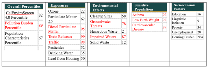
COMMENT: CAL ENVIROSCREEN SCORES FOR PACIFIC PLACE year 2020
Census Tract: 6037572100 (Population: 1,113)
The results for each indicator range from 0-100 and represent the percentile ranking of census tract 6037572100 relative to other census tracts.
Census Tract: 6037572100 (Population: 1,113)
Cal enviroscreen legend image
CalEnviroScreen 4.0 Final Results
COMMENT: This project proposes 457 parking stalls:
• 1,681 self-storage units
• 426 rentable recreational vehicle parking stalls
• 26 standard automobile parking stalls, and 5 ADA accessible automobile parking stalls.
Request 12) The estimated additional traffic and emissions should be calculated in the EIR. The current CAL Enviroscreen ratings/percentiles should be compared with a calculation of the additional emissions and the effect the project would have on air quality.
COMMENT: The South Coast Regional Air Quality Board (including our then Long Beach City Councilmember – now Mayor, Rex Richardson) passed a landmark rule in May 2021 targeting warehouses over 100,000 sq ft because of the emissions associated with diesel trucking and applying penalties and restrictions on behalf of clean air.
The proposed warehouse in this project is over 200,000 sq feet, and while diesel trucking is not part of the target use, carbon emissions from cars and RVs will increase pollution and be problematic for the surrounding population.
REQUEST 13) Evaluate the content and reasoning behind that rule and determine if the current proposed project has similar threats to public health and safety. Determine if there are any ramifications of the new rule that would affect the proposed project and compare results for the alternate uses being explored.
NOISE
REQUEST 14) Noise should be calculated before any work begins, how much noise will impact the residents and school during construction and what the expected noise level will be throughout a 24 hour day after the proposed project is complete.
BIOLOGICAL IMPACTS
COMMENT: The Fish and Wildlife letter that was submitted to comment on the Mitigated Negative Declaration (MND) for this property has extensive comments on biological impacts.
REQUEST 15) We ask that the EIR include responses to the questions and topics raised by Fish and Wildlife in their response to the MND. We have attached their file 135. 2020-11-17 Dept_of_Fish_and_Wildlife_Att 351 and ask that you use it as incorporation into our comments.
COMMENT: The grading of the site that took place in Aug 2020 (without an approved Mitigated Negative Declaration) in preparation for the surcharge testing caused the disappearance/destruction of 820 native southern tarplants, considered a sensitive species. Initially there was a report that they had been removed and transplanted. Later it was disclosed they were gone. This plant is considered “rare, threatened, endangered.”
REQUEST 16) The EIR needs to include the southern tarplant count from before the surcharge grading. The description of sensitive species needs to include the 820 tarplants that were identified in 2020 and provide mitigation for their replacement. The current plant count on the site needs to also be included.

Illustration 6 Southern Tarplant
COMMENT: Noted in the MND “ Potentially suitable foraging and roosting habitat for the big free-tailed bat is present on the McDonald Trust parcels.” There was also vegetation onsite that had the potential to be used for nesting by birds protected under the Migratory Bird Treaty Act (MBTA) and the California Fish and Game Code Section 3503. It was reported that DTSC allowed the removal of plants and trees in preparation for the surcharge test.
REQUEST 17) The EIR should reference the species involved, dates of plant removal along with the permits that were obtained. Any plant, tree, bird or wildlife information that provided observations and counts before the surcharge test should be included in this EIR. Mitigation for losses should be included.
Recreation
COMMENT: There is a park equity issue in our city where the eastside has 17X more parkland than the westside. The westside has higher density, lower incomes with more black & brown inhabitants. The city has a stated goal of 5 acres per 1000 people and this westside area has only 1 acre per thousand residents. The city has lost its open space at an alarming rate with business and residential development taking precedence. The west side of Long Beach has been severely short changed with respect to parkland.
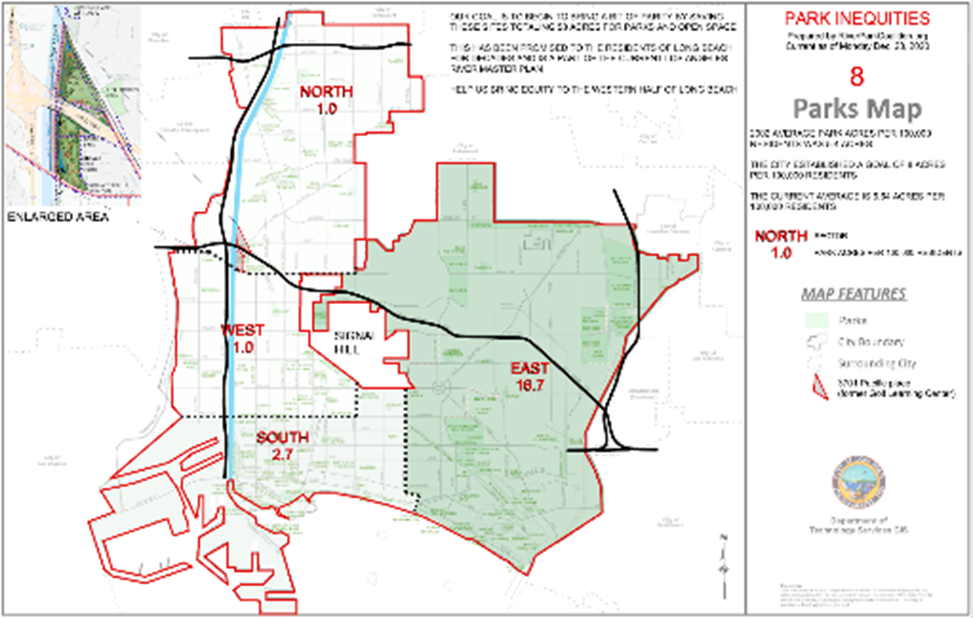
Illustration 7: Park Equity – Acres per 1000 residents
REQUEST 18) The EIR should include the topic of park equity describing the current inequities and the potential to close the gap on the proposed project and project alternatives. The city goal for parkland is 5 acres per 1000 residents.
Geology and Soils
COMMENT: The public deserves a thorough investigation of the area to understand the content and depth of contaminated soil (said to be 30-50 feet deep). DTSC did shallow soils sample testing for lead, arsenic and TPH (total petroleum hydrocarbons). Other contaminants were reported in earlier publications to include benzene, organic and inorganic compounds. Shallow depth testing would not be adequate for this site.
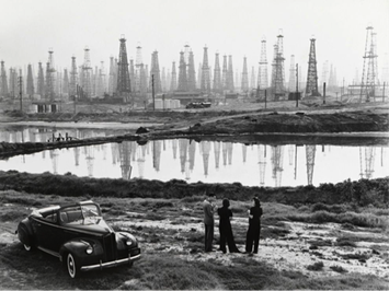
Illustration 8 Photo of a Long Beach oil fields sump pond 1941
REQUEST 19) A soils company should be engaged to drill core samples, test for a larger range of contaminants and provide advice on what lies beneath the surface down to a reasonable depth (50 ft?). Included in the report should be “elevated concentrations” along with “acceptable limits” that are considered healthy.
Transportation
COMMENT: The proposed project that includes 1,681 self-storage units, 426 rentable recreational vehicle parking stalls and 26 standard automobile parking stalls, with 5 ADA accessible automobile parking stalls. One can assume there will be a good deal of automobile and RV traffic. With CEQA focused on “vehicle miles travelled,” VMT calculations will have to make assumptions that may or may not be grounded in reality. The VMT calculation should be supplemented by a traffic study that shows the impact on the neighborhood.
REQUEST 20) Identify VMT assumptions and provide calculations. Assumptions should be based on reasonable facsimile to the location and size of the proposed project.
REQUEST 21) Also engage a traffic engineer to prepare a traffic study that identifies entrance and egress from freeway offramps; provides volume expectations; calculates whether all sizes of recreational vehicles can navigate the roundabouts without incident; and how the increase in vehicles affects traffic patterns at different hours of the day.
Greenhouse Gas Emissions
COMMENT: This project has already removed trees and the plan is to pave over the area which will increase heat retention.
Request 22) Compare this project with alternative projects including a parkland alternative and quantify the net effect of trapping and reflecting heat by installing cement. The Long Beach Climate Adaptation Plan should be referenced for their recommendations.
Tribal Cultural Resources
COMMENT: This area was a known location for first peoples and requires investigation of the use of the site. There are local descendants of the first peoples in the area that should be interviewed for their knowledge of the use of this area.
REQUEST 23) Contact tribal members and/or descendants to obtain information on the early site usage and what may potentially be found there. A tribal member should be identified that can be on site if artifacts or graves are found.
Hazards and Hazardous Materials
COMMENT: As this site has a significant history in being a dumping ground for the oil industry, it would be advisable to do extensive research and testing to find out what lies beneath the surface. There should be a thorough cleanup of the site removing the hazardous materials from the oil brine treatment facility that was on the site when Oil Operators Inc owned the property. It should be a thorough cleanup, not just a cover up. Just below the surface, the area is said to be the consistency of toothpaste.
Request 24) Expected outcomes of climate change that may affect the area should be included in the EIR.
Request 25) The results of the soils investigation and water quality may include identification of hazardous materials and gases that require mitigation. We ask that you document what it would take to clean up the site, removing the contaminated soil.
Request 26) The site lies in the direct path of the Newport-Inglewood Fault line, with recent seismic activity, and major earthquake, seismic and liquefaction impacts due to fault(s) that affect this location which should be identified in the EIR.
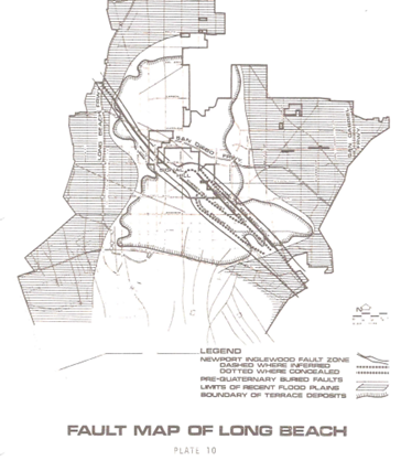
llustration 9 Fault Map of Long Beach
Utilities and Service Systems
COMMENT: The large business that is being contemplated for this location will require all the utilities services such as trash, water, sewer, gas, street sweeping, electrical etc. Additionally, there would need to be monitoring of gaseous emissions if the contaminated soil is not removed and replaced.
REQUEST 27) All of the above services should be included in the EIR with estimates on usage and whether the work can be absorbed. The gaseous emissions need particular attention with respect to how it would be handled, whether for a storage facility or a park.
Hydrology and Water Quality
COMMENT: Flood control risks – The storm drain infrastructure is currently incapable of handling the rain run off for current density in the City of Long Beach vicinity. There are known flooding issues, and the need for a mitigation plan to control any such conditions and to assess the site specific impacts that will or may contribute to the cumulative negative flood impacts known to occur with run off toward the river to the west and equestrian communities to the south. Impacts must be assessed, site specific and broader reaching areas due to factors such as topographical features and history of flooding in the vicinity.
REQUEST 28) LA Co Flood Control District should be consulted for correcting, documenting, reporting or sufficiently mitigating for future flooding in the vicinity, as they have combined responsibility with the City of Long Beach via storm water NPDES permit requirements, 1999 Maintenance and use Agreement with the Army Corps of Engineers, 1996 & 2006 & 2020 LA River Master Plans.
COMMENT: Ground-water contamination may have occurred with all the chemicals that have been dumped at this site and that are possibly still leaching through the soil. Historical documentation indicates that brine, acid sludge, refinery effluent, and other waste were discharged into scores of bored “cesspools,” into undrained sumps and pits, or onto the land surface. The Geologic Surveys from various eras may be useful in tracing conditions at the site. There are said to be several decommissioned oil wells on this property and their status should be included in the EIR as well.
REQUEST 29) Whatever documentation currently exists on ground water quality should be researched and referenced. Testing may need to be done if the information is not current. Old oil wells on the property should be found and their condition made part of the EIR.
COMMENT: There was significant disturbance to the soil during surcharge testing. A storm drain pipe runs under the proposed building site. Placing significant weight on the pipe probably damaged it and whether contaminants have been allowed to be transported into the LA River needs investigation. This issue was not previously studied and should be included in the EIR process.
REQUEST 30) Determine the condition of the storm drain pipe under the surcharge test area and whether hazardous contaminants are being leached into the LA River.
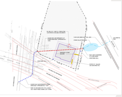
Illustration 10 storm drain pipe beneath proposed building site under surcharge soil
Recent Comments